Browse categories
- Trending 🔥Trending 🔥
- Publish Your Book
- Book Design
- Book Editing
- Book & eBook Marketing
- Children's Book Illustration
- Beta Reading
- Convert to eBook
- Book & eBook Writing
- Create Your Website
- E-commerce & Dropshipping
- Shopify
- WordPress
- Website Design
- E-Commerce Marketing
- Graphics & DesignGraphics & Design
- Logo & Brand Identity
- Logo Design
- Brand Style Guides
- Business Cards & Stationery
- Fonts & Typography
- Art DirectionNew
- Logo Maker Tool
- Art & Illustration
- Illustration
- AI Artists
- AI Avatar DesignNew
- Portraits & Caricatures
- Comic IllustrationNew
- Cartoon Illustration
- Storyboards
- Album Cover Design
- Pattern Design
- Tattoo Design
- Miscellaneous
- Design Advice
- Web & App Design
- Website Design
- App Design
- UX Design
- Landing Page Design
- Icon Design
- Print Design
- Brochure Design
- Flyer Design
- Packaging & Label Design
- Poster Design
- Catalog Design
- Menu Design
- Books & eBooks
- Book Design
- Book Covers
- Book Layout Design & Typesetting
- Children's Book Illustration
- Comic Book IllustrationNew
- Visual Design
- Image Editing
- AI Image EditingNew
- Presentation Design
- Resume Design
- Infographic Design
- Vector Tracing
- Marketing Design
- Social Media Design
- Email Design
- Web Banners
- Signage Design
- Architecture & Building Design
- Architecture & Interior Design
- Landscape Design
- Building Engineering
- Lighting Design
- Fashion & Merchandise
- T-Shirts & Merchandise
- Fashion Design
- Jewelry Design
- Programming & TechProgramming & Tech
- Website Development
- Business Websites
- E-Commerce Development
- Custom Websites
- Landing Pages
- Dropshipping Websites
- Languages & Frameworks
- Python
- React
- Java
- React Native
- Flutter
- AI Development
- AI Websites & SoftwareNew
- AI Mobile AppsNew
- AI Integrations
- AI Automations & Agents
- AI Fine-Tuning
- AI Technology ConsultingNew
- Mobile App Development
- Cross-platform Development
- Android App Development
- iOS App Development
- Mobile App Maintenance
- Cloud & Cybersecurity
- Cloud Computing
- DevOps Engineering
- Cybersecurity
- Digital MarketingDigital Marketing
- Search
- Search Engine Optimization (SEO)
- Generative Engine OptimizationNew
- Search Engine Marketing (SEM)
- Local SEO
- E-Commerce SEO
- Video SEO
- Social
- Social Media Marketing
- Paid Social Media
- Social Commerce New
- Influencer Marketing
- Online Communities
- Channel Specific
- TikTok Shop
- Facebook Ads Campaign
- Instagram Marketing
- YouTube Promotion
- Google SEM
- Shopify Marketing
- Methods & Techniques
- Video Marketing
- E-Commerce Marketing
- Email Marketing
- Email Automations
- Marketing Automation
- Guest Posting
- Affiliate Marketing
- Display Advertising
- Public Relations
- Crowdfunding
- Text Message Marketing
- Scale Your Marketing With AI
- AI Marketing Prompt Strategy
- Brand Personality Design
- Email Marketing Personalization
- AI-Powered Campaign Management
- AI-Powered Ad Bidding & Automation
- Analytics & Strategy
- Marketing Strategy
- Marketing Concepts & Ideation
- Conversion Rate Optimization (CRO)
- Conscious Branding & Marketing New
- Web Analytics
- Marketing Advice
- Let us manage your project
- Industry & Purpose-Specific
- Music Promotion
- Podcast Marketing
- Mobile App Marketing
- Book & eBook Marketing
- Self-Publish Your Book
- Video & AnimationVideo & Animation
- Editing & Post-Production
- Video Editing
- Visual Effects
- Intro & Outro Videos
- Video RepurposingNew
- Video Templates Editing
- Subtitles & Captions
- Social & Marketing Videos
- Video Ads & Commercials
- Social Media Videos
- Music Videos
- Slideshow Videos
- Let us manage your project
- Motion Graphics
- Logo Animation
- Lottie & Web Animation
- Text Animation
- Animation
- Character Animation
- Animated GIFs
- Animation for Kids
- Animation for Streamers
- Rigging
- NFT Animation
- Filmed Video Production
- Videographers
- Filmed Video Production
- Writing & TranslationWriting & Translation
- Content Writing
- Articles & Blog Posts
- Content StrategyNew
- Website Content
- Scriptwriting
- Creative Writing
- Podcast Writing
- Speechwriting
- Research & Summaries
- Find an Expert Writer
- Book & eBook Publishing
- Book & eBook Writing
- Book Editing
- Beta Reading
- Books & literature translation
- Self-Publish Your Book
- Business & Marketing Copy
- Brand Voice & Tone
- Business Names & Slogans
- Case Studies
- Product Descriptions
- Ad Copy
- Sales Copy
- Email Copy
- Social Media Copywriting
- Press Releases
- UX Writing
- Translation & Transcription
- Translation
- LocalizationNew
- Transcription
- InterpretationNew
- Industry Specific Content
- Business, Finance & Law
- Health & Medical
- Internet & Technology
- News & Politics
- Marketing
- Real Estate
- Music & AudioMusic & Audio
- Music Production & Writing
- Music Producers
- Composers
- Singers & Vocalists
- Session Musicians
- Songwriters
- Jingles & Intros
- Custom SongsNew
- Let us manage your project
- Audio Engineering & Post Production
- Mixing & Mastering
- Audio Editing
- Vocal Tuning
- Voice Over & Narration
- 24hr Turnaround
- Female Voice Over
- Male Voice Over
- French Voice Over
- German Voice Over
- Sound Design
- Sound Design
- Meditation Music
- Audio Logo & Sonic Branding
- Custom Patches & Samples
- Audio Plugin Development
- Lessons & Transcriptions
- Online Music Lessons
- Music Transcription
- Music & Audio Advice
- BusinessBusiness
- Business Formation & Consulting
- LLC Registration
- Business Formation & RegistrationNew
- Market Research
- Business Plans
- Business Consulting
- HR Consulting
- AI Consulting
- Operations & Management
- Virtual Assistant
- Project Management
- Software Management
- E-Commerce Management
- Supply Chain Management
- Customs & Tariff AdvisoryNew
- Event Management
- Product Management
- Legal Services
- Intellectual Property ManagementNew
- Legal Documents & Contracts
- Legal Research
- General Legal Advice
- Finance
- AI ServicesAI Services
- AI Mobile Development
- AI Mobile AppsNew
- AI Websites & SoftwareNew
- AI Chatbot
- AI Integrations
- AI Automations & Agents
- AI Fine-Tuning
- AI Technology ConsultingNew
- Let us manage your project
- AI Artists
- AI Avatar DesignNew
- ComfyUI Workflow Creation
- AI Image EditingNew
- Midjourney Artists
- Stable Diffusion Artists
- All AI Art Services
- AI for Businesses
- AI Consulting
- AI Strategy
- AI Lessons
- Personal GrowthPersonal Growth
- Fashion & Style
- Modeling & Acting
- Styling & Beauty
- Trend ForecastingNew
- Gaming
- Game Coaching
- Marvel Rivals CoachingNew
- eSports Management & Strategy
- Game MatchmakingNew
- Ingame Creation
- Gameplay Experience & FeedbackNew
- Game Recordings & Guides
- ConsultingConsulting
- Business Consultants
- Legal Consulting
- Business Consulting
- HR Consulting
- AI Consulting
- Business Plans
- E-commerce Consulting
- Marketing Strategy
- Marketing Strategy
- Content Strategy
- Social Media Strategy
- Influencers Strategy
- Video Marketing Consulting
- SEM Strategy
- PR Strategy
- Coaching & Advice
- Career Counseling
- Life Coaching
- Game Coaching
- Styling & Beauty Advice
- Travel Advice
- Nutrition CoachingNew
- Mindfulness CoachingNew
- Traveling
- DataData
- Data Science & ML
- Machine LearningNew
- Computer Vision
- NLP
- Deep Learning
- Generative Models
- Time Series Analysis
- Data Analysis & Visualization
- Data Analytics
- Data Visualization
- Data Tagging & Annotation
- Dashboards
- Data Processing & Management
- Data Processing
- Data Governance & Protection
- Databases & Engineering
- Databases
- Data Engineering
- PhotographyPhotography
- Products & Lifestyle
- Product Photographers
- Food Photographers
- Lifestyle & Fashion Photographers
- People & Scenes
- Portrait Photographers
- Event Photographers
- Real Estate Photographers
- Scenic Photographers
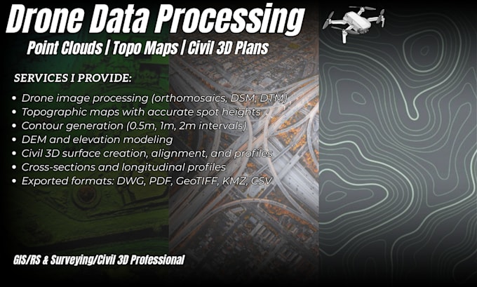
- Drone Photographers New
- Local Photography
- Photographers in New York
- Photographers in Los Angeles
- Photographers in London
- Photographers in Paris
- All Cities
- Miscellaneous
- Photography Classes
- Photo Preset CreationNew
- Other