Browse categories
Explore
Fiverr Pro
English
$
USD

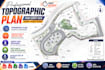
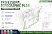
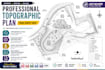
Welcome to my Topographic Plan Gig!
Are you looking for a professional and accurate topographic plan from survey data? You are in the right place.
I am a Civil Engineer and AutoCAD Civil 3D specialist with experience in creating topographic plans, contour maps, site plans, subdivision layouts, and land survey drawings for residential, commercial, and land development projects.
Services Included:
Topographic Plans
Contour Maps & Contour Lines
Survey Data Processing
AutoCAD Civil 3D Drafting
Site Plans
Spot Elevations
Existing Ground Surface Plans
Subdivision Layout Plans
Land Development Drawings
DWG, PDF, and JPG Deliverables
Why Choose Me?
Accurate and professional work
Fast delivery
High-quality CAD drawings
Civil 3D expertise
Friendly communication
100% customer satisfaction
Software Used:
File Formats:
DWG | PDF | JPG
Please contact me before placing an order to discuss your project requirements.
Keywords: Topographic Plan, Topographic Survey, Contour Map, Contour Lines, Site Plan, Land Survey, AutoCAD Civil 3D, Survey Data Processing, Subdivision Plan.
Please inform the freelancer of any preferences or concerns regarding the use of AI tools in the completion and/or delivery of your order.
Languages
What information do you need to create a topographic plan?
I can work with survey points, CSV files, TXT files, point clouds, DWG files, PDF surveys, and other survey data provided by the client.
Which file formats will I receive?
I can deliver files in DWG, PDF, and JPG formats. Other formats can be provided upon request.
Can you create contour lines from survey data?
Yes, I can generate accurate contour lines and contour maps from survey points, point clouds, and existing survey drawings.
Do you use AutoCAD Civil 3D?
Yes, I use AutoCAD Civil 3D and AutoCAD to create professional topographic plans and land development drawings.
Can you handle large commercial or subdivision projects?
Yes, I can prepare topographic plans, site plans, subdivision layouts, and cadastral maps for residential and commercial projects.


