Browse categories
Explore
Fiverr Pro
English
$
USD

Data Scientist, AI Python Developer and GIS Specialist
Skills
See my services
Senior Data Science
Zoneomics • Full-time
Jul 2023 - Present • 2 yrs 11 mos
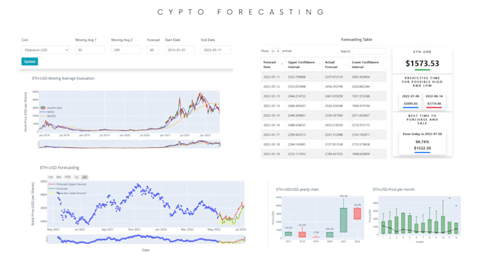
Implementing and Handling Multiple Project some includes: • FADIP Pipeline Development: Designed a Python-based pipeline to process raw geometries, PLUs, and control data, transforming and storing them in PostgreSQL, boosting data flow efficiency and accuracy. • Designed and documented a comprehensive suite of Elasticsearch Mustache-based search templates to power parcel - and zoning-level analytics across different indices. Implemented dynamic filters, aggregation logic, and performance-optimized query flows supporting city, FLUM, PLU, and ZIP-based data retrieval — forming the backbone for internal BI dashboards and map-based search UIs. • Developed a FastAPI-based Zoning Extractor microservice integrating PostgreSQL, Jinja2 UI, and OpenAI LLMs to automate extraction of zoning controls and land-use data from municipal documents. • AI Zoning Agent Development: Built a Python-based AI agent using LangGraph to automate zoning research workflows, including web scraping, email extraction, and response classification, significantly reducing manual effort. • Parking Data Extraction Project: Automated extraction of parking-related data from municipal documents using web scraping, machine learning models, and LLMs. • Permits Data Extraction Project: Extracted and processed permit data from ArcGIS and city websites, structuring it with LLMs and indexing in Elasticsearch for quick retrieval. • IMDAD System Development: Built a Python-based backend system that automatically detects changes in city geometries by fetching data in real time from various ArcGIS sources and notifies updates, ensuring accurate and timely data management in PostgreSQL.
