Browse categories
Explore
Fiverr Pro
English
$
USD


Need to analyze satellite imagery and understand environmental or land-cover changes?
I will perform professional remote sensing and satellite image analysis using GIS and raster-processing workflows.
Services include:
Satellite image processing and analysis
NDVI and vegetation analysis
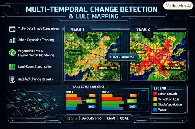
Multi-temporal change detection
Land-cover classification
Raster analysis and reclassification
DEM and terrain-based analysis
Image comparison and thematic mapping
Remote sensing data visualization
I can work with suitable satellite imagery and raster datasets, including GeoTIFF and other common geospatial formats.
Depending on your package, I can process the imagery, apply the required analysis workflow, compare multiple dates, and deliver clear analytical maps and outputs.
Tools: QGIS, ArcGIS Pro, ENVI, and GDAL workflows.
Please contact me before ordering if you have specific satellite imagery, dates, study areas, classification requirements, or technical specifications.
GIS Geospatial Analyst Mapping Spatial Analysis
Languages
What remote sensing analyses can you perform?
I can perform NDVI analysis, change detection, land-cover classification, raster analysis, image comparison, and other GIS-based remote sensing workflows depending on the project requirements.
Can you analyze satellite images from different dates?
Yes. I can compare suitable multi-temporal satellite imagery to identify and visualize spatial changes between different dates.
Can you perform NDVI analysis?
Yes. I can calculate and visualize NDVI from suitable multispectral satellite imagery and provide a clear analytical map.
Do I need to provide the satellite imagery?
You can provide the imagery if you already have it. If you are unsure which imagery or data is appropriate, contact me before ordering so we can confirm the required dataset.
Can you perform land-cover classification?
Yes. I can perform GIS-based land-cover classification using suitable satellite imagery and the agreed classification requirements.
Can you analyze a specific study area?
Yes. Please provide the area boundary, coordinates, location, or another suitable Area of Interest (AOI).