Browse categories
English
$
USD
Connect to your AI


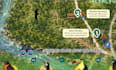
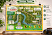

I design custom tourism maps, hiking trail maps, and thematic maps for ecotourism destinations and outdoor projects.
MY SERVICES
WHAT YOU MUST PROVIDE
You must supply all information to be included in the map, such as:
I will organize and integrate your content into a professional, customized design. Research, writing, field surveys, and complex geographic data corrections are not included in the standard packages.
MY PROCESS
We will discuss your requirements and agree on the content and design before I start. Clear communication throughout the project is essential.
DELIVERY
High-resolution PNG and PDF files. An editable CorelDRAW file is included in the Premium package.
Please contact me before ordering to discuss your project.
Spanish is my native language, and I can communicate in English also.
Please inform the freelancer of any preferences or concerns regarding the use of AI tools in the completion and/or delivery of your order.
Tourism and Thematic Map Designer
Languages
What information do I need to provide?
You must provide the geographic data, locations, texts, descriptions, recommendations, signs, symbols, and other information you want included in the map. Please also provide any logos or images you want to use. We will discuss the requirements before I start.
Can you create the map if I don't have geographic files?
No, please contact me first. I can review the location information you have and determine whether it is sufficient for your project. Geographic data creation, field surveys, and complex data preparation are not included in the standard packages.
Do you write descriptions or research information about attractions and wildlife?
No. You must provide the exact text, recommendations, safety instructions, and descriptions you want displayed on the map. Research and content writing are not included in the standard packages.
Can you include custom signs, icons, and recommendations?
Yes. I can integrate signs, icons, recommendations, and other visual elements into the design. You must specify which elements you need, what they should represent, and provide the corresponding text or instructions.
What file formats will I receive?
You will receive high-resolution PNG and PDF files. An editable CorelDRAW source file is included in the Premium package. Please contact me if you need another format.
Can I request changes to the map?
Yes. Each package includes a specific number of revision rounds. Revisions cover adjustments to the agreed design. New routes, additional locations, major design changes, or new content outside the original scope may require an additional payment.


