Browse categories
Explore
Fiverr Pro
English
$
USD

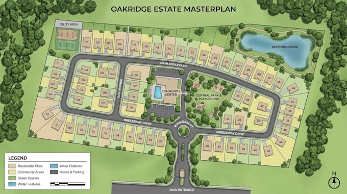
Transform your estate development concept into a clear, organized, and professionally presented masterplan. I specialize in estate layout mapping, plot numbering, access road arrangements, and property layout plans that help landowners, developers, and real estate investors visualize proposed developments and communicate their plans effectively.
WHAT I OFFER
1. Estate Masterplan Illustrations
2. Residential Plot Layouts
3. Plot Numbering & Identification
4. Access Road Layouts
5. Property Layout Map
6. Land Subdivision Plans
7. Lot & Parcel Arrangements
8. Neighborhood Development Map
9. 2D Site Layout Plans
10. Custom Land Development Map
WHY CHOOSE MY SERVICE
- Clear and organized estate presentation
- Consistent plot numbering and identification
- Well-structured road and access layouts
- Customized visuals for your project requirement
Whether you are planning a residential estate, organizing property plot, or presenting a proposed land development, Ill help turn your site information into a polished and easy-to-understand masterplan.
Present your estate project with confidence through a professional masterplan that communicates your layout, plots, and access routes.
Please inform the freelancer of any preferences or concerns regarding the use of AI tools in the completion and/or delivery of your order.
Professional Map Designer, GIS and Custom Mapping
Languages
What information do you need to create my land development map?
Please provide a sketch, existing map, aerial reference, property information, labels, and any available boundary or plot details.
Can you customize the map to match my project or brand?
Yes. I can tailor the colors, labels, plot numbering, road illustrations, and overall visual style to your supplied requirements.
Can I use the illustrated map for official land subdivision approval?
The gig provides visual illustrations, not certified survey or approval drawings. Official submissions may require work from appropriately qualified local professionals.