Browse categories
Explore
Fiverr Pro
English
$
USD


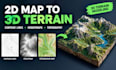
Do you have contour lines, a topographic map, or a heightmap that you want to turn into a 3D terrain model?
I can help transform your terrain data into a detailed 3D landscape using Blender and suitable terrain-modeling workflows.
Whether you need a mountain range, hills, valleys, elevation-based terrain, or a 3D representation of a real location, I will work with your provided data to create a model suited to your intended use.
WHAT I CAN HELP YOU CREATE
WHAT YOU WILL RECEIVE
Please contact me before ordering if you have unusual source files, large geographic areas, specific scale requirements, or a specialized GIS or 3D-printing workflow.
Let's turn your terrain data into a useful 3D model!
Please inform the freelancer of any preferences or concerns regarding the use of AI tools in the completion and/or delivery of your order.
3D Terrain Artist Landscape Modeling Heightmaps
Languages
What files do you need to create a 3D terrain model?
I can work with suitable heightmaps, contour-line data, topographic maps, elevation data, or reference images. Please contact me first if you are unsure whether your file is suitable.
Can you create terrain from contour lines?
Yes, provided the contour data is suitable for reconstruction. The complexity depends on the file format, contour quality, spacing, and amount of elevation information available.
Can you create terrain from a real-world location?
Potentially, yes. Please provide the location and explain your requirements. The availability and suitability of elevation data will determine the workflow and scope.
Which file formats can you deliver?
Depending on your requirements and the model, delivery may include OBJ, STL, or FBX. Please confirm the desired format before ordering.
Can you create terrain for 3D printing?
Yes, for projects within the agreed scope. The model may require a solid base, suitable wall thickness, mesh repair, and other preparation to make it printable.
Can I request a specific terrain size or scale?
Yes. Include the required dimensions or scale before ordering. Physical dimensions and geographic scale are different requirements, so please specify which one matters to your project.
Do you provide the source project file?
This depends on the selected package and agreed scope. If you need the editable Blender project file, please request it before ordering.
What if my terrain data is incomplete?
Send me the available files first. I will review them and explain what can reasonably be created before accepting the project.
