With over 5 years of experience as a GIS Analyst, I have a proven track record in creating GIS maps using industry-leading software like ArcGIS, Golden Software, and QGIS. I am well-versed in various tools including Golden Software's Surfer, QGIS open source environment, Global Mapper, and ArcGIS.
My services encompass a wide range of GIS solutions tailored to your needs. I can assist you with:
- Coordinate Systems: Ensuring accurate and properly defined coordinate systems for your GIS projects, ensuring spatial accuracy and seamless data integration.
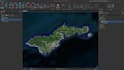
- Creating Maps from Google Earth: Transforming Google Earth data into visually appealing and customized maps that effectively communicate spatial information.
- Shapefiles, Geodatabases, KML, and More: Working with different file formats, including shapefiles, geodatabases, KML, and more, to handle your data effectively and ensure compatibility across platforms.
- Spatial Analysis: Conducting comprehensive spatial analysis to extract meaningful insights from your geographic data. This can involve spatial querying, overlay analysis, proximity analysis, and hotspot identification.
Feel free to contact!