Browse categories
Explore
Fiverr Pro
English
$
USD

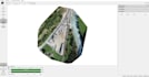
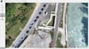
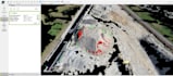

Professional photogrammetry processing for images captured with drones, cameras or mobile devices. I will process your dataset using Pix4D and Agisoft Metashape to generate accurate 3D and mapping deliverables for surveying, construction, architecture, agriculture, environment, real estate and planning projects.
Depending on your package and image quality, deliverables may include orthomosaic maps, dense point clouds, DSM, DTM, contour lines, textured 3D mesh, elevation maps, processing report and CAD/GIS-ready files.
Available outputs may include GeoTIFF, LAS/LAZ, OBJ, PLY, XYZ, DXF, SHP, KML/KMZ, JPG or PDF.
Please note: final results depend on image quality, overlap, lighting, camera parameters, ground visibility and whether GCPs or accurate coordinates are provided. DTM, contours and georeferenced outputs are available when the dataset allows accurate processing.
Expert in Drones, 3D, Photogrammetry, and Orthomosaics
Languages


