Browse categories
Explore
Fiverr Pro
English
$
USD

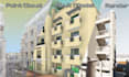
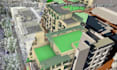
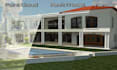

Need an accurate Revit model from your point cloud scan?
I offer professional Scan to BIM services to convert laser scans into clean, detailed Revit models for architecture, structure, and MEP. As a BIM Manager with real-world project experience, I deliver high-quality results tailored to your needs.
I work with E57, RCP/RCS, LAS, and more to create Revit models at LOD 200 to 400, suitable for design, coordination, and as-built documentation. Whether its a single room, full floor, or complete building, I ensure models are organized, accurate, and aligned with your standards or BEP.
Lets bring your scan data to life! Contact me before ordering to discuss your project and get a custom offer.
Fiverr does not screen freelancers in this category. Please verify qualifications and discuss requirements with the freelancer before ordering, including any preferences regarding the use of AI tools.
Languages
What deliverables can I expect?
A clean Revit File with custom Families for the As-Built model so that you can document and or design with ease.
What Levels of Development (LOD) do you model?
I can model up to LOD500 in most cases, but for Scan to BIM, the standard is LOD200. I can really only model what the scanner can see, therefor some details like hidden services (piping) or structural reinforcing is difficult to see / model.
Which point-cloud formats do you accept?
Commonly accepted formats include .RCP/.RCS (Autodesk Recap), .E57, .LAS. If you have a .LGS file, this will also help a lot. If you need me to clean up the point cloud I would required the original .RCP File in order to get all the functionality you require.
Can you work on Geo-referenced projects?
Yes I can. This would require that you provide me with a CAD Drawing from which I can Acquire Coordinates, or the intended Project Base point with the Point Cloud Coordinated on the same Base Point.


