Browse categories
Explore
Fiverr Pro
English
$
USD



Good decisions need a spatial model you can check, explain and run again.
I am an agricultural meteorologist and certified GISP with nearly 20 years of spatial analysis for the United Nations and the World Bank. I build geospatial decision support models and deliver them in ArcGIS, QGIS or computational notebooks your team can rerun on new data.
What I build:
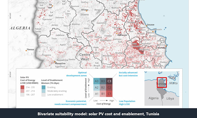
- Priority and suitability models with adjustable weights and scenarios
- Travel-time catchments, trip flows and road bottlenecks
- Machine learning land cover, such as yearly forest cover
- Overlay, proximity and zonal statistics per boundary
- Earth Engine workflows that summarize satellite data at scale
Example: a corridor model that scores 1-km cells for infrastructure priority and maps 30 to 120-minute catchments around top sites.
Tools: ArcGIS, QGIS and other FOSS4G tools, Google Earth Engine, Python and Jupyter Notebook.
How I work:
- We agree the method before any modeling starts
- Code, notes and results sit together, so every step can be checked
- All packages include maps, GIS data and a method note
Every project differs in data, method and output, so message me for a custom offer.
Exploring Climate with GIS and Data Science
Languages
What kind of models can you build?
Any model that can be written as spatial rules, weights or equations: site suitability, investment priority, hazard exposure, accessibility, land cover change and more. Tell me the question and I will propose the approach.
Will I get a QGIS project or a notebook?
Whichever your team uses. Desktop users get a QGIS project or model; teams that code get a documented notebook that runs in Google Colab or local Jupyter. Premium includes a full reproducible notebook project.
I do not have any data. Can you still help?
Yes. I can source open data such as satellite imagery, land cover, elevation, population, roads and climate records. Add the data sourcing extra, or message me first to check what exists for your area.
Do I need a Google Earth Engine account?
Only to rerun the Earth Engine parts yourself, since Earth Engine needs a registered account and cloud project. I can guide you through setup, or export the data so the work runs without it.
Which machine learning methods do you use?
For land cover, tree-based models such as Random Forest and gradient boosting, trained with spatial cross-validation so accuracy is not overstated. The choice depends on your labels and data.
Which package should I choose?
Basic for one analysis on data you already have. Standard for a model of one area with several inputs. Premium when you need scenarios, a sensitivity check and a model you can rerun yourself.
Are the package prices fixed?
No, they are a starting point. The real scope depends on your data, the method and the outputs you need. Message me with the details and I will send a custom offer that fits your project.
Can my team learn to rerun the analysis?
Yes. Inputs and parameters sit in one place, the method note documents every step, and the Presentation option adds a recorded walkthrough.
Is my data kept confidential?
Your data is used only for your order and is never shared. If you ask, I delete it after delivery.