Browse categories
Explore
Fiverr Pro
English
$
USD

Level 2
Expert in GIS and Remote Sensing
Skills
See my services


Want to work on an hourly basis?
Tell Bramantiyo M what you need.
$15
/
hourGeospatial Data and Information Chief
Center of Data Processing, Indonesian Ministry of Public Works and Housing • Full-time
Aug 2019 - Feb 2022 • 2 yrs 6 mos
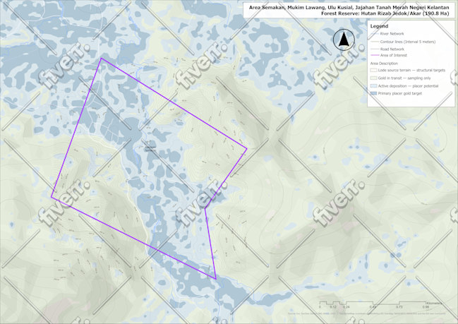
In this position, I build and manage (along with my team) : 1. Geospatial Data Production and Analysis using well known GIS Techs such as ArcGIS, QGIS, ENVI, ERDAS, PCI, and many related software. 2. Managing and Developing agency geoportal backed by ESRI ArcGIS Ecosystem. The portal now is still live at : https://sigi.pu.go.id 3. Geospatial Information Production in Maps, Dashboards, Presentations, Web Map Services about infrastructure and disaster related themes according to my office tasks and duties.
GIS Officer
Indonesian Ministry of Public Works • Full-time
Jan 2011 - Sep 2019 • 8 yrs 8 mos
In this position, my roles are: 1. Geospatial Data Production and Analysis using well known GIS Techs such as ArcGIS, QGIS, ENVI, ERDAS, PCI, and many related software. 2. Managing and Developing agency geoportal backed by ESRI ArcGIS Ecosystem. The portal now is still live at : https://sigi.pu.go.id 3. Geospatial Information Production in Maps, Dashboards, Presentations, Web Map Services about infrastructure and disaster related themes according to my office tasks and duties.
GIS Officer
United Nations Development Programme • Full-time
Jul 2008 - Dec 2010 • 2 yrs 5 mos
In this position, My job are: 1. Producing Maps, Perform Spatial Analysis, doing Geospatial Field Survey to assist Humanitarians Effort in Indonesia. 2. Producing Reports related to Spatial Analysis in various theme related to UNDP activities in Indonesia 3. Volunteering in disaster Management efforts, perform 5W1H Mapping for every major disaster that happened in Indonesia during the time of employment
| (108) | ||
| (1) | ||
| (0) | ||
| (0) | ||
| (0) |

maga2020

United States
excellent work. provided exactly what we asked for. will definitely use again.
joekeither
Repeat Client
United States
Delivered excellent work. I look forward to working with him again.

joekeither
Repeat Client
United States

joekeither
Repeat Client
United States
Provided what I needed in a quick and timely manner
Up to $50
Price
3 days
Duration
accw28

Hong Kong