Browse categories
Explore
Fiverr Pro
English
$
USD

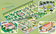


Isometric Illustrated Maps
I create bespoke isometric maps that transform locations into immersive views. Perfect for brand experiences, interactive websites, event venues, and campaigns that want to stand out from the crowd.
My isometric illustrations don't just map out a space; they provide a birds-eye perspective that brings depth, clarity, and a premium, playful aesthetic to your project. By blending architectural precision with character-driven storytelling, I turn layouts into engaging destinations.
What's included:
Do you have a project that requires a unique angle or doesn't fit into the predesigned packs? No worries, I can create a custom offer, just write me, and we'll design the perfect isometric view for your vision.
Please inform the freelancer of any preferences or concerns regarding the use of AI tools in the completion and/or delivery of your order.
Professional illustrator and visual storyteller
Languages
What do you need to get started?
A brief description of the location or space, reference materials (plans, sketches, photos if available), landmarks to highlight, and any brand guidelines. If needed, I can help define the best visual approach at the start.
Can you match my color scheme or brand guidelines?
Absolutely! Just let me know from the beginning your preferred color palette, branding, or style references and they will be applied to the map
Do I get commercial rights for the artwork?
Yes, commercial rights for use in print media, web, and social is included. For extended usage (paid ads, merchandise, OOH, etc.) contact me for a custom offer.
Can you create maps for print and large formats?
Yes, these maps are created in vector based software, which allows to increase the size without losing quality
Do you provide the vector open file?
Only included in the Premium pack. For the other packs Vector/layered open files (adobe illustrator file) are an add-on. You can buy it separately.


