Browse categories
Explore
Fiverr Pro
English
$
USD
Level 2


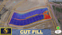


I am an Expert with MSc Degree in GIS having 15+ years' industry experience in Contour Maps, Topographical Plans, Digital Elevation Modeling, and Surveying to transform raw survey data or GIS data into high-accuracy maps for engineering, site planning, and land development.
Services Offered:
Features to include in Topographic Plan:
Accuracy Guaranteed.
Please contact me before placing an Order!
Please inform the freelancer of any preferences or concerns regarding the use of AI tools in the completion and/or delivery of your order.
Pro Experts in GIS, Mapping, 3D Models, Drones, and Civil Engineering
Level 2
Languages
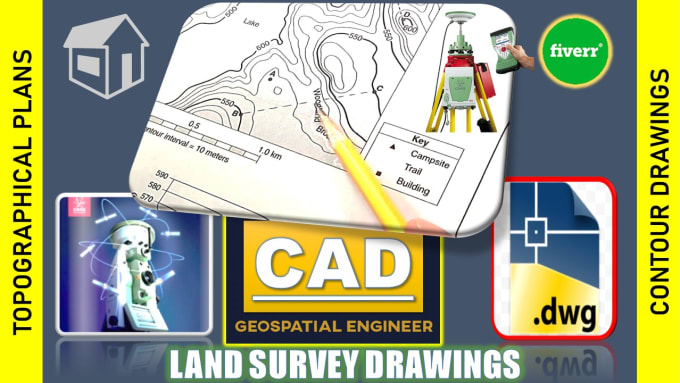
What is included in your Land Survey & Topo Plan services?
My services cover a range of tasks including processing land survey point data, plotting data from various surveying instruments (Total Station, GPS, DGPS, GNSS, Laser Scanning), creating Records of Survey (ROS) for parcel lots, site plans, and more.
What is Land surveying?
Land surveying is the technique, science and engineering of establishing or reestablishing corners, lines, boundaries, and monuments of real property (land) based upon recorded documents, historical evidence, and present standards of practice.
What are the types of Land Survey?
1- Construction or Engineering: studies changes in property lines, the location of buildings, road topography and grade. 2- Geodetic: uses satellite and aerial imaging to measure large portions of the earth. 3- Boundary or Land: determines where properly lines are located.
What equipment is needed to conduct a Land Survey?
Land Surveying could be performed from any of the following instruments / Techniques. 1- Total Station (X, Y, Z) 2- Differential Global Positioning System (DGPS) 3- Laser Scanner 4- Stereo Satellite Imagery 5- Drone Images 6- Theodolite 7- Level (sight level, laser level or water level)
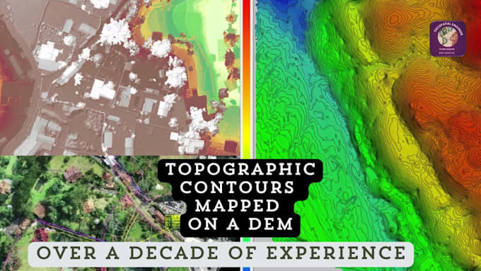
What are Contour Lines and Topographic Maps?
Put simply, contour lines mark points of equal elevation on a map. Topography is the study of geographical features on a landscape. A map with contour lines on it is called a topographic map. Essentially, topographic maps represent the three-dimensional landscape of Earth within 2D space of a map.
What level of detail can I expect in the contour map?
The level of detail in the contour map will depend on the quality and quantity of the survey point data provided. Generally, I aim to produce highly detailed and accurate contour maps that faithfully represent the topography of the surveyed area.
Can you include specific features or annotations in the contour map?
Yes, I can include additional features or annotations such as roads, buildings, water bodies, or any other relevant information upon request. Just let me know your specific requirements, and I'll do my best to accommodate them.
How will the final product be delivered?
The final contour map will be delivered in AutoCAD format (.dwg) or JPG map. Other file formats may be available upon request.
What is the typical turnaround time for this service?
The turnaround time varies depending on the size and complexity of the area to be mapped, as well as the current workload. I strive to deliver high-quality results within a reasonable timeframe, and I'll provide you with an estimated delivery date upon receiving your order.
How can I get started with your services?
To get started, please contact me before placing an order. This allows us to discuss your project requirements, clarify any questions or concerns you may have, and ensure that I can provide the best possible service tailored to your needs.
| (15) | ||
| (1) | ||
| (0) | ||
| (0) | ||
| (0) |

lynntaylor

United States
Thank you!!!!!!!!!!!!!!!!!!!!!
$50-$100
Price
5 days
Duration
ricmed372
United States
Thank you. I appreciate the work.
$100-$200
Price
5 days
Duration
jasonwarner845

Costa Rica
Thank you once again.
Up to $50
Price
3 days
Duration
jasonwarner845
Costa Rica
Highly responsive - highly professional output. I asked for a few edits and they came back better than I asked for. I will seek Geospatial out the next time I need similar services.
$100-$200
Price
8 days
Duration

amcodev

Canada
Delivered work as requested. Highly recommend.
$50-$100
Price
8 days
Duration
| (15) | ||
| (1) | ||
| (0) | ||
| (0) | ||
| (0) |
lynntaylor
United States
Thank you!!!!!!!!!!!!!!!!!!!!!
$50-$100
Price
5 days
Duration
ricmed372
United States
Thank you. I appreciate the work.
$100-$200
Price
5 days
Duration
jasonwarner845
Costa Rica
Thank you once again.
Up to $50
Price
3 days
Duration
jasonwarner845
Costa Rica
Highly responsive - highly professional output. I asked for a few edits and they came back better than I asked for. I will seek Geospatial out the next time I need similar services.
$100-$200
Price
8 days
Duration
amcodev
Canada
Delivered work as requested. Highly recommend.
$50-$100
Price
8 days
Duration