Browse categories
Explore
Fiverr Pro
English
$
USD
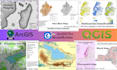
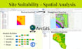
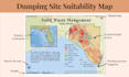
Hello! If you are looking for a professional GIS analyst and cartographer, you are in the right place.I have 4+ years of experience in using ArcGIS and QGIS to create maps, perform spatial analysis, and handle GIS data for research, business, and environmental studies.
I can help you with:
Mapping & Cartography
Spatial & Statistical Analysis
Remote Sensing & Classification
Web & Advanced GIS
You Will Receive
Contact me before placing order
Languages
What data do I need to provide?
You can provide spatial data (Shapefile, GeoJSON, KML, CSV with coordinates) or tabular data with location information. If you don’t have data, I can guide you on how to collect or source it.
What software do you use?
I work with both ArcGIS and QGIS, ensuring compatibility and professional output for all mapping needs.
Can you work with my own style or branding?
Yes! I can customize colors, fonts, and layouts to match your brand or project requirements.
Will my data remain confidential?
Absolutely. Your data will only be used for your project and will not be shared with anyone.
What if I need something not listed in the packages?
You can message me before ordering with your specific requirements, and I’ll create a custom offer for you.
Do you provide editable project files?
Yes, I can provide the editable GIS project file upon request (additional cost may apply).


