Browse categories
Explore
Fiverr Pro
English
$
USD
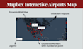
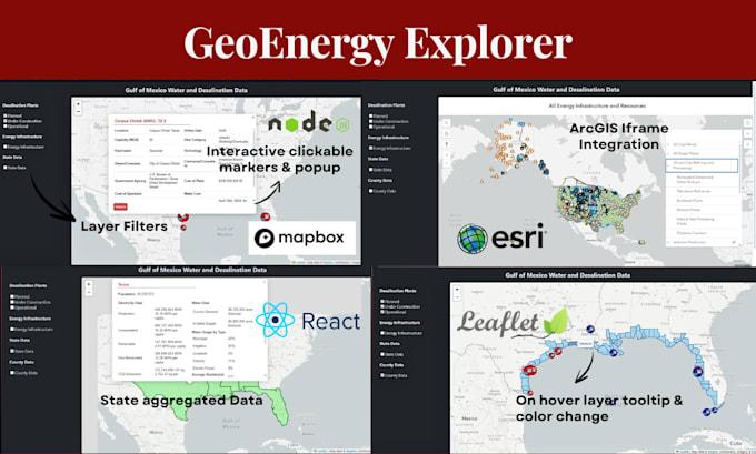
Hi, I'm a certified GIS specialist and web map developer. I create interactive, responsive, and data-driven maps that make your spatial data easy to understand and explore. Whether you need a simple location map or a complex application with live data, Ive got you covered.
What I can build for you:
Technologies I work with:
Why choose me:
From real estate maps to environmental dashboards, Ill make sure your map isnt just functional its something your audience will love us
Languages
What do you need from me to get started?
I’ll need your spatial data (GeoJSON, shapefiles, CSV, or API link), project requirements, preferred design/style, and any branding guidelines you’d like applied to the map.
Can you work with my existing GIS data?
Yes! I can work with shapefiles, GeoJSON, KML, CSV, or database connections. I can also help you clean and prepare your data if needed.
Will my map work on mobile devices?
Absolutely. All maps I create are fully responsive and optimized for mobile, tablet, and desktop screens.
Can you integrate my map with a live database or API?
Yes, I can connect your map to PostgreSQL/PostGIS, MongoDB, or any API for real-time data updates and filtering.
Do you provide hosting for the web map?
I can guide you on free and paid hosting options such as GitHub Pages, Netlify, Vercel, or your own server. Hosting setup can also be included in the order.
Can you add advanced features like heatmaps, clustering, or filtering?
Yes! I can implement heatmaps, point clustering, custom popups, legends, filters, and animations as part of your map’s functionality.
What technologies do you use?
I mainly work with React.js, angular Leaflet.js, Mapbox GL JS, OpenLayers, Node.js, and PostgreSQL/PostGIS, combined with GIS tools like ArcGIS Pro and QGIS for data preparation.