Browse categories
Explore
Fiverr Pro
English
$
USD

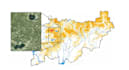

I create maps for your research, projects, dissertations and academic papers. I work in Qgis, I know Maxent - a programme for predicting the distribution of species. I can combine Maxent visualisation in Qgis, use GBIF.
Languages
What kind of cards are there?
Simple - Plotting points or polygons on a specific region, without using statistics. Medium - Use of climatic, biological, geographical, hydrological data in mapping, statistics on raster data (WorldClim, Chelsa, Envirem, Bio-Oracle, Permafrost). Complex - Use of Maxent, with quite statistical jus
What databases are you working with?
With species distribution data: GBIF, INATURALIST. With climatic and biological data: Worldclim, Chelsa, bio-Oracle, Permafrost, Envirem. With geologic and soil data. I can separately study the question you are interested in, and make an individual order.
What programs do you have?
What programs do you have? I own Gis system Qgis. I own MaxEnt species distribution forecasting program. I know R studio programming language. Statistical methods of analysis in Exel.
Can you explore the issue of building a personalized specific map?
Yes


