Browse categories
Explore
Fiverr Pro
English
$
USD
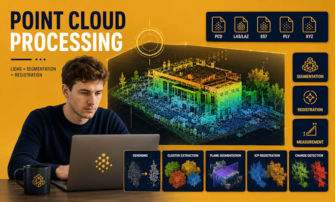
I will develop custom point cloud processing software for LiDAR, laser scanning, reality capture, digital twin, BIM, surveying, robotics, autonomous systems, and industrial inspection workflows.
Whether you need a desktop application, cloud platform, automation tool, REST API, or custom processing pipeline, I can build scalable software capable of handling large point cloud datasets and complex spatial analysis workflows.
My solutions support industry-standard formats including PCD, PLY, LAS, LAZ, E57, XYZ, and PointCloud2 data streams.
Features
PCD, LAS, LAZ, E57, PLY and XYZ processing
Point cloud import and export tools
LiDAR data processing pipelines
Voxel grid downsampling
Statistical outlier removal
Radius outlier filtering
Point cloud denoising
Point cloud segmentation
RANSAC plane extraction
Euclidean cluster extraction
Region growing segmentation
ICP registration and alignment
Global registration using FPFH and RANSAC
Point cloud merging and stitching
Multi-scan registration workflows
Floor plan generation from scans
Point cloud measurement tools
Deviation inspection reports
Point cloud annotation tools
ROS PointCloud2 integration
Real-time LiDAR streaming
and more...
3D Reconstruction, Point Cloud, LiDar, Revit, AutoCAD, Data Science
Languages
