Browse categories
Explore
Fiverr Pro
English
$
USD

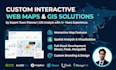
Are you looking to turn complex spatial data into an engaging, user-friendly digital experience?
As an independent consultant and Town Planner | GIS Analyst with 4+ years of experience, I build custom interactive web maps tailored to your needs. From simple visualizations to full-stack applications, I bridge the gap between geographic data and accessible interfaces.
What I Offer:
My Expertise: I don't just write code; I understand the urban principles behind the data. I combine meticulous graphic design with technical accuracy to ensure your map is both beautiful and highly functional.
Why Choose Me? ️
Contact me before ordering!
Let's put your ideas on the map.
Best Regards,
Thulnith Sathviru.
Please be aware that it is against Fiverr's policies for sellers to include themes, templates, or any other elements that infringe third-party rights or applicable laws in the delivered work. Read more about in our Guide to Responsible Digital Creation.
Professional Expertise, High Quality Results, Zero Hassle
Languages
What data formats do you accept?
I can work with almost any spatial or tabular data format, including Shapefiles (.shp), GeoJSON, KML/KMZ, Geodatabases, or even simple Excel/CSV files with latitude and longitude coordinates. If your data needs cleaning or geocoding first, just let me know!
Can you host the web map so it is live on the internet?
Yes! For basic and standard maps, I can help you deploy them for free using platforms like GitHub Pages, Vercel, or Netlify. For premium full-stack applications (React/Flask/MongoDB), I can guide you through setting up proper cloud hosting.
Do you provide the source code upon completion?
Absolutely. All packages include the final, well-documented source code. This ensures you or your team have full ownership and can make future updates if needed.
I have raw data, but it needs spatial analysis first. Can you do that?
Yes. As a Town Planner and GIS Analyst, I don't just build the web interface. I can perform complex data processing, spatial joins, density analysis, and apply methodologies like AHP or Space Syntax to your data before visualizing it.
What if I have a massive dataset with thousands of points?
For very large datasets that might slow down a standard web browser, I recommend the Premium package. I can set up a backend database (like MongoDB) and optimize the data using vector tiles or clustering to ensure the map loads quickly and runs smoothly.
Can you match the map's design to my company's branding?
Definitely. I have extensive experience in graphic design and can customize the map's colors, basemap style, popups, and typography to perfectly match your brand guidelines or project aesthetics.
Which package should I choose?
If you just need to display a few points or polygons on a map, choose Basic. If you need interactive filtering, legends, and spatial analysis visualization, choose Standard. If you need a complete database-driven web application with user interaction, choose Premium. When in doubt, send me a message


