Browse categories
Explore
Fiverr Pro
English
$
USD

Spatial Data Analyst
Skills
See my services
Junior Data Analyst
Garudalytics Private Limited • Full-time
Feb 2024 - Jun 2025 • 1 yr 4 mos
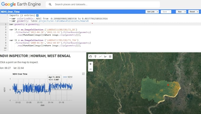
I was responsible for analyzing geospatial datasets, both raster and vector, using Python and GIS software such as ArcGIS Pro and QGIS. My role also involved developing custom geoprocessing tools within both ArcGIS and QGIS environments to enhance spatial data processing workflows. I have hands-on experience in deploying custom-trained object detection models in an offline (no-internet) environment on a Django backend during a defense project. In addition, I trained deep learning models on custom datasets to detect military objects from satellite imagery. Within the Django server, I developed and deployed tools for object pattern recognition, object change detection, and object movement analysis. I contributed to the development of GeoAI tools for Garudalytics’ flagship product, GSM. These tools included solutions for heatwave prediction, flood depth and impact analysis, building footprint extraction, wildfire impact analysis, and crop yield prediction, thereby supporting advanced geospatial intelligence applications. To streamline and automate specific georeferencing workflows, I developed a custom georeferencing and mosaicking tool using PyQt5. This tool significantly improved efficiency in handling large-scale spatial datasets. I also created Disha, a QGIS plugin designed to calculate least-cost routes for specific and strategic use cases, enabling optimized pathfinding in critical scenarios. In addition to development work, I prepared comprehensive technical documentation and maintained cloud repositories for various tools and solutions developed across projects and proof-of-concepts (PoCs). This ensured smooth collaboration, version control, and long-term maintainability of the solutions.
