Browse categories
Explore
Fiverr Pro
English
$
USD

Level 1

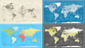


*** Welcome to Your One-Stop World Map Design Gig! ***
Are you looking for a High-Quality, Custom-Made world map? You're in the right place! I specialize in creating professional maps for various purposes educational, business, travel, web use, or artistic presentations.
️Services I Offer:
*** Special Maps (Geographical Maps)***
What You Get:
Why hire me:
Lets create something beautiful and informative
Please inform the freelancer of any preferences or concerns regarding the use of AI tools in the completion and/or delivery of your order.
Provide a high quality and reliable Maps
Level 1
Languages
What type of world maps can you create?
I can design political, physical, artistic, or vector-based world maps — either labeled or blank. Let me know your specific need!
Can I print the map in large format?
Yes! I can deliver high-resolution files suitable for printing in any size.
Can I request a custom color scheme or labels?
Yes. Just let me know your preferred colors or text, and I’ll design the map accordingly.
Do you use real GIS data for the maps? (if you offer GIS maps)
Yes, I use GIS software (QGIS or ArcGIS) to create maps based on accurate global data when needed.
Can I get the source/editable files to resize the map later?
Absolutely. If you choose the Standard or Premium package, I’ll include editable files (AI, PDF, or SVG formats).


