Browse categories
Explore
Fiverr Pro
English
$
USD

Level 1


Stop answering the same questions about available lots, campsites, units, or properties. An interactive property map gives your visitors a clear visual overview of your site while providing the details they need with a simple click or hover.
I create custom interactive lot maps for campgrounds, RV parks, subdivisions, apartment communities, marinas, resorts, and other property developments. Each map is designed to match your layout and can display lot numbers, availability status, property details, links, and more.
Whether you need a simple map showing available sites or a fully interactive solution connected to your existing data, I can build a system that is easy to understand and maintain.
My background combines mapping, data management, process improvement, and dashboard development, allowing me to create tools that are both visually appealing and practical for day-to-day operations.
If your project has unique requirements, send me a message before ordering. I am always happy to discuss custom solutions and larger developments.
Please inform the freelancer of any preferences or concerns regarding the use of AI tools in the completion and/or delivery of your order.
Dedicated to meeting and exceeding your expectations!
Level 1
Languages
What types of properties can you create maps for?
I can create interactive maps for campgrounds, RV parks, subdivisions, apartment communities, marinas, resorts, mobile home parks, and other property developments. If your property has lots, units, sites, or parcels, I can likely build a solution for it.
What information can be displayed on the map?
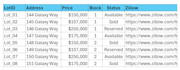
Maps can display lot numbers, availability status, ownership, pricing, amenities, property details, booking links, Zillow listings, contact information, and more. Every project is customized to your needs.
Do I need to provide a map or site plan?
Yes. To ensure accuracy, you should provide a site plan, aerial image, plat map, or existing property layout. The more information you provide, the better the final result will be.
Can the map be updated later?
Absolutely. Maps can be designed for future updates, and I offer maintenance services for clients who need availability, ownership, or property information updated regularly.
Will this work on my website?
Yes. Interactive maps are designed to be embedded on websites and can include clickable lots, hover details, status indicators, and external links depending on the package selected.
Can you import my existing spreadsheet data?
Yes. I can import data from spreadsheets or CSV files and connect that information to the map, making future updates much easier to manage.


