Browse categories
Explore
Fiverr Pro
English
$
USD
Ukraine
I will create a Python script to calculate distances from CSV data
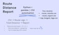
I will create a clean route distance report from your CSV file using Python.
What you get:
- Distance for each route leg (Stop A Stop B Stop C...)
- Total route distance summary
- Top 10 longest legs (useful for logistics and planning)
- Output files in a clear format (CSV + report.txt)
Input format:
CSV with columns: stop, lat, lon
Deliverables:
- route_results.csv (distance per leg)
- top_longest_legs.csv (top 10 longest legs)
- route_report.txt (human-readable summary)
If your data contains invalid coordinates, I will mark them clearly instead of crashing the script.
Message me if youre not sure about the CSV format I can quickly check it.
Portfolio (GitHub): delivery zones tool + route report tool (available on request).
I can also share sample output files (CSV + report) before you order.
If you have addresses only (no coordinates), I can geocode small datasets to lat/lon first, then generate the route report.

Technology:
Excel
•
Google Sheets
•
Python
•
VBA
•
Zapier
•
Other
Can you work with addresses (not coordinates)?
This gig works with latitude/longitude. If you have addresses only (no coordinates), I can geocode small datasets to lat/lon first, then generate the route report.
What if my CSV has errors?
Invalid coordinates will be marked clearly, and the report will still be generated.
What will I receive?
CSV results + a readable report.txt summary.
