Browse categories
Explore
Fiverr Pro
English
$
USD
Data Engineer, Local AI Specialist and Master of Urban Development
Need OpenStreetMap data but don't know how to extract it? I'll get you clean, ready-to-use geodata from any city worldwide.
As an urban planner and GIS specialist, I extract custom OSM data filtered exactly to your needs:
WHAT YOU GET:
PERFECT FOR:
I use Python automation with Overpass API to ensure accurate, up-to-date data extraction. You tell me the city and what data you need - I handle the technical part.
No subscriptions, no complicated GIS software needed. Just clean data ready for your project.


Technology:
Excel
•
Python
What areas do you cover?
Worldwide! OpenStreetMap has data for almost every city globally. Coverage is best in Europe and North America, but I can extract data from any region where OSM exists.
How recent is the data?
I pull data directly from OpenStreetMap's live database, so it's as current as OSM contributors keep it (usually very up-to-date in major cities).
Do I need special software to open the files?
No! CSV and Excel open in any spreadsheet program. GeoJSON works with free tools like QGIS or online viewers. I'll include instructions.
Can you extract data for multiple cities?
Yes! Choose the premium gig or contact me for custom bulk orders.
What if the data I need isn't in OpenStreetMap?
I'll let you know before starting. OSM is very comprehensive for infrastructure and POIs, but some niche data might be incomplete. I can suggest alternatives if needed.
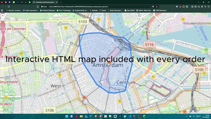
Do you provide maps or just raw data?
Basic & Standard = raw data files. Premium includes a simple visualization map if need. For advanced cartography, check my other gigs or request a custom order.