Browse categories
Explore
Fiverr Pro
English
$
USD


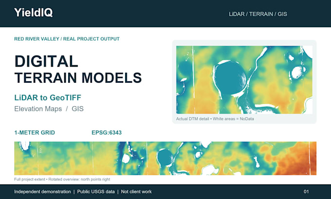
Turn your ground-classified LiDAR data into a Digital Terrain Model (DTM) and clear elevation maps with YieldIQ.
Using CloudCompare and QGIS, I process suitable LAS/LAZ files into terrain deliverables for GIS visualization and preliminary site review.
Depending on your package, deliverables include:
DTM GeoTIFF
Elevation map with legend
Hillshade visualization
PDF map layout
Overview and detail maps
PDF report with processing notes
Please provide ground-classified LAS/LAZ data, the coordinate reference system, project boundary, desired grid resolution, and intended use.
Package limits: Basic up to 10 million points, Standard up to 25 million, and Premium up to 50 million, covering one continuous area.
Pricing assumes data is ready for terrain generation. Cleaning, ground classification, larger datasets, and special requirements need a custom quote. Please message me before ordering so I can confirm suitability.
Grid resolution depends on source data and does not guarantee accuracy. Deliverables are not a certified survey or engineering design.
My portfolio includes an independent demonstration using public USGS LiDAR data.
Owner LiDAR and GIS Data Processing Specialist
Languages
What files do I need to provide?
Please provide ground-classified LAS or LAZ files, the coordinate reference system, your project boundary, and desired output resolution. If you are unsure whether your data is suitable, message me before ordering.
Does this gig include LiDAR cleaning or ground classification?
Standard package pricing assumes your data is already ground-classified. Noise filtering and ground classification are available through a separate service or custom quote.
What will I receive?
Every package includes a DTM GeoTIFF and elevation map. Higher packages add hillshade visualization, a PDF map layout, detail mapping, or a report, as listed in the package.
Can you create a 1-meter DTM?
Yes, when the source data supports it. Grid resolution depends on point spacing, ground coverage, and intended use. A 1-meter grid does not mean 1-meter accuracy.
Can you process more than 50 million points?
Please contact me for a custom quote. I will review the file size, coverage, requested outputs, and processing requirements before confirming price and delivery.
Will gaps in the data be filled?
Empty areas remain NoData unless we agree on a suitable gap-filling method. Any agreed interpolation will be documented.
What does a revision include?
Revisions cover changes to map colors, labels, legends, and layout within the original scope. New data, expanded coverage, or changes requiring reprocessing may cost extra.
Can I use the results for surveying or engineering?
These deliverables support GIS visualization and preliminary review. They are not a certified survey or engineering design, and no independent accuracy assessment is included.
Is your portfolio example client work?
The Red River Valley example is an independent demonstration using public USGS LiDAR data, not commissioned client work.