Browse categories
Explore
Fiverr Pro
English
$
USD


Hello!
Are you looking for a professional Elevation Map?
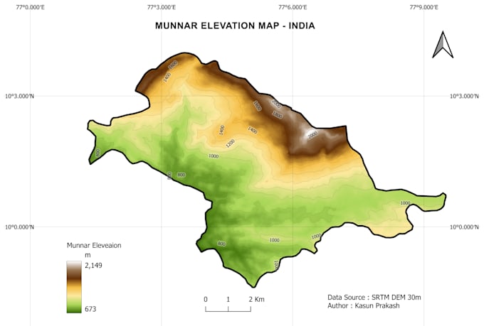
I will create a high-quality Elevation / Terrain / Contour map from DEM data using QGIS.
What you will get: High-resolution map (300 DPI, JPG + PDF), Custom Elevation Color Ramp (Green to Brown/White), Contour Lines with Labels (as you need), Hillshade and Slope Map, All Map Elements (North Arrow, Scale Bar, Legend, Graticule), Source Data: SRTM 30m, ALOS 12.5 m.
Perfect for,
Thesis, Research Papers, Reports, Presentations, Academic Projects.
Why Me? QGIS Specialist, Fast Delivery, Portfolio work - See my Munnar Elevation Map example.
Please contact me before ordering with your Study Area location (KML/Shapefile or just a place name).
GIS Undergraduate
Languages
1. What do you need from me to start the map?
You just need to send me your study area. You can send a Google Maps pin, Place Name (Ex: Munnar, India), KML file, or Shapefile. That's enough. I will find the DEM data myself.
2. What data source do you use for elevation maps
I use high-quality open source DEM data. Mainly SRTM 30m, ALOS PALSAR 12.5m and ASTER GDEM. If you have your own DEM (like Drone survey DEM), you can send me that too.
3. Can you add my own study area boundary or roads to the map?
Yes! I can add your Shapefile, KML, roads, rivers, buildings, or any layer you provide on top of the elevation map for free in Standard & Premium packages.
4. What files will I receive after delivery?
You will get High-Resolution JPG (4000px), Print-ready PDF (300 DPI), and in Premium package you will get QGIS project file and GeoTIFF DEM. All maps will be ready to use for your Thesis or Report.
5. Can you make a 3D Hillshade or 3D view of the terrain?
Yes. I can create Realistic 3D Hillshade, Slope Map, Aspect Map and 3D QGIS 3D View. This is included in Standard and Premium.
6. How fast can you deliver?
I can deliver a basic elevation map within 6-12 hours. For urgent delivery, please contact me before ordering. I offer 24-hour delivery for all packages.