Browse categories
Explore
Fiverr Pro
English
$
USD


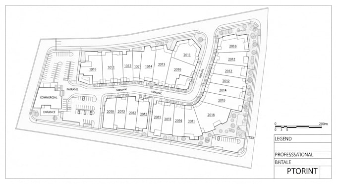
Looking for a professional property plan, site plan, or land subdivision thats accurate, permit-ready, and designed in AutoCAD?
Youre in the right place!
I specialize in creating 2D plot plans, site layouts, lot plans, and subdivision drawings for building permits, zoning approval, and land development. Every plan is tailored to local city or county requirements for fast approval.
My Services Include:
Whether you need a simple residential plot plan or a detailed commercial site layout, I provide high-quality, precise, and professional AutoCAD plans that meet your project goals.
Lets get your plan approved quickly and professionally!
Please inform the freelancer of any preferences or concerns regarding the use of AI tools in the completion and/or delivery of your order.
Expert in Permit Ready Architectural, Structural, MEP Drawings Title
Languages
Can you create plans that are approved for city or county permits?
Yes! All my drawings are made to meet permit, zoning, and planning department requirements. I ensure every plan is accurate, scaled, and ready for submission.
What if I only have a hand sketch or Google Map image?
No problem — I can convert your sketch, image, or survey into a professional AutoCAD site plan suitable for permit or planning use.
What file formats will I receive?
You’ll get PDF, DWG (AutoCAD), and PNG formats, ready for printing or digital submission.
Can you modify or update an existing site plan?
Yes, I can edit, update, or redraw existing plans to include new structures, setbacks, or property changes.
Do you provide 3D or only 2D plans?
This gig focuses on 2D property, plot, and site plans for permits and approvals, but I can provide 3D visualization as an add-on upon request.
How accurate are your plans?
All plans are drawn using AutoCAD with precise scaling and dimensions, based on your provided data (survey, measurements, or GIS info).
What do I need to get started?
You’ll need to send: Property address or location Sketch or survey (if available) Desired scale and measurements Purpose (permit, planning, etc.)