Browse categories
English
$
USD
Connect to your AI

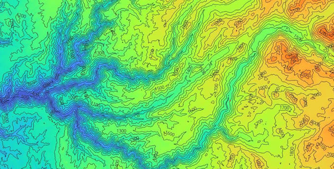
Need to understand the terrain of your study area? I process digital elevation models (DEM) and turn them into clear, ready-to-use maps and data.
WHAT YOU GET
- Contour lines at the interval you choose, as shapefile
- Slope and aspect maps with clear classification and legend
- Hillshade for a realistic view of the relief (Premium)
- Final layout with scale bar, north arrow and legend (Premium)
- Raster outputs in GeoTIFF, maps in high-resolution PNG/PDF
WHAT I NEED FROM YOU
- Your area of interest (coordinates, shapefile or region name)
- Your own DEM, or I can use a public one (SRTM, Copernicus...)
- Contour interval and slope classes, if you have preferences
IDEAL FOR
Geological and geomorphological studies, landslide and hazard analysis, hydrology, land planning, theses and reports.
WHY ME
I'm a geoscience student with hands-on experience in terrain analysis, fieldwork-based geological mapping and remote sensing. I work with ArcGIS Pro and Python.
Not sure which package you need? Message me before ordering and I'll help you choose.
GIS and Geospatial Analyst, QGIS and ArcGIS Pro
Languages
Can you use my own DEM?
Yes, send it in GeoTIFF or a similar raster format. If you don't have one, I can use a free public DEM, such as SRTM or Copernicus, and tell you its resolution first.
How detailed will the contour lines and slope be?
It depends on the DEM resolution. Free global DEMs have a resolution of about 30 m, which suits regional studies, not detailed local ones. If you need more detail, send me a higher-resolution DEM.
Which formats do you deliver?
Contour lines as shapefile, rasters as GeoTIFF, maps as PNG or PDF. Other formats on request.
Is there a limit to the area size?
Large areas take longer and can exceed the package. If your area is big, message me before ordering and I'll confirm the price and timing.
| (1) | ||
| (0) | ||
| (0) | ||
| (0) | ||
| (0) |
arean8221

Germany
> Luca was very responsive, friendly and patient throughout the project. He sourced the official regional terrain data, added the protected trees to the model in the revision and tested a grid of positions, which gave me a solid basis for choosing the building location. The first version of the report...
$100-$200
Price
10 days
Duration
| (1) | ||
| (0) | ||
| (0) | ||
| (0) | ||
| (0) |
arean8221
Germany
> Luca was very responsive, friendly and patient throughout the project. He sourced the official regional terrain data, added the protected trees to the model in the revision and tested a grid of positions, which gave me a solid basis for choosing the building location. The first version of the report...
$100-$200
Price
10 days
Duration
