Browse categories
Explore
Fiverr Pro
English
$
USD

GeoAI Architect, Spatial Data Scientist and GIS Specialist
Skills
See my services
Geographic Intelligence & Spatial Statistics Consultant
Independent Consultancy • Self-employed
Feb 2022 - Present • 4 yrs 5 mos
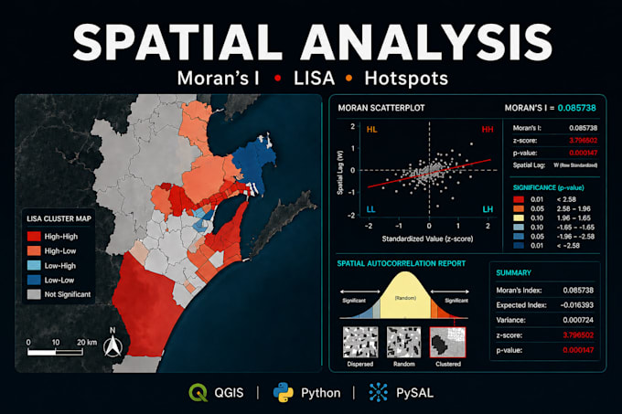
As an Independent Consultant, I specialize in the full Geospatial Data Science cycle, providing technical rigor for strategic decision-making. Key Achievement: Socioeconomic & Urban Vulnerability Analysis - Developed an in-depth study using Spatial Statistics (Global and Local Moran's I - LISA) to scientifically validate non-random clusters. - Managed the complete data pipeline: from mining and structuring large census datasets to advanced geocoding and complex spatial modeling. - The project was praised by a board of PhDs for its technical excellence and post-graduate level methodological rigor. Core Deliverables: - Advanced Thematic Cartography and Territorial Diagnostics (QGIS). - Spatial Autocorrelation & Modeling (ArcGIS / QGIS). - Visual Intelligence Dashboards and Data Storytelling. - Urban Legislation analysis and geometry compatibility. I help AI companies and urban managers transform raw, complex data into high-precision ground truth and actionable insights.
