Browse categories
Explore
Fiverr Pro
English
$
USD


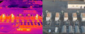
Drone mapping and survey data processing: orthomosaics, DSM/DTM, point clouds, thermal, and multispectral analysis. Handled by a GACA and GEOSA-licensed geospatial operator.
Two ways to use this gig:
Processing deliverables:
Toolchain: RealityCapture, Pix4D, ArcGIS, QGIS. Outputs are GIS and CAD compatible.
Accuracy note: absolute accuracy depends on your GCPs or RTK/PPK data. Achievable accuracy is stated before work begins. No accuracy claim is made without supporting checkpoints.
On-site RTK capture, full agricultural field surveys, and large-area mapping inside Saudi Arabia are quoted per project. Message for a custom offer with scope and coordinate system.
Languages
Can you fly the site yourself?
On-site capture in Saudi Arabia is available by custom offer (RTK/PPK, GCPs, coordinate system defined per project). These fixed tiers process imagery you supply.
What image overlap do you need?
For mapping, 70-80% front and side overlap is recommended. Lower overlap may reduce coverage and accuracy; this is reviewed before processing.
What coordinate systems do you support?
Common UTM and national grids including KSA-GRF17. Specify your required CRS when ordering.


