Browse categories
Explore
Fiverr Pro
English
$
USD
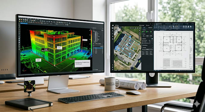
Do you need accurate measurements from LiDAR scans, point clouds, drone imagery, or 3D models?
I will develop custom 3D measurement software for surveying, construction, engineering, inspection, digital twin, mapping, and industrial applications.
My solutions can automatically calculate dimensions, distances, heights, areas, volumes, and object measurements from point clouds, LiDAR data, images, or reconstructed 3D scenes.
Services Included
LiDAR Data Processing
Point Cloud Measurement
Distance and Dimension Calculation
Area and Volume Measurement
Drone Mapping Analysis
Photogrammetry Measurement Tools
3D Scanning Applications
Construction Measurement Systems
Surveying Software Development
Digital Twin Measurement Tools
Industrial Inspection Solutions
CAD Data Integration
Automated Reporting Dashboards
Custom Desktop or Web Applications
Technologies
OpenCV
Open3D
Python
PCL
LiDAR Processing
Photogrammetry
COLMAP
Reality Capture
Drone Mapping Workflows
Industries
Construction
Surveying
Architecture
Mining
Engineering
Agriculture
Manufacturing
Infrastructure Inspection
Whether you need a measurement tool for drone surveys, LiDAR scans, 3D models, or inspection workflows, I can build
Programming language:
Python
•
R
•
MATLAB
•
Colab
•
Java
Frameworks:
Scikit-learn
•
DeepPy
•
Google ML Kit
•
SimpleCV
•
PyTorch
