Browse categories
Explore
Fiverr Pro
English
$
USD

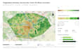
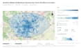
Need a professional, accurate GIS map for your project?
I can help you turn your geographic data into clear, high-quality maps using QGIS and ArcGIS Pro.
With professional experience in GIS, spatial analysis, and environmental mapping, I have produced over 45 thematic maps for technical and environmental studies.
My GIS mapping services include:
Why work with me?
Basic Package ($30): One professional GIS map using your prepared spatial data, delivered within 3 days, including one revision.
Advanced spatial analysis, extensive data cleaning, and additional maps require a custom offer.
Please message me before ordering! Tell me about your project, available data, and expected results. I'll help you find the right GIS mapping solution.
GIS Analyst specializing in QGIS, ArcGIS and Spatial Data
Languages
What do you need from me to create a GIS map?
Please provide your GIS data (Shapefile, GeoJSON, GeoPackage, KML, or other supported formats), the purpose of your map, and any preferred colors, labels, or layout requirements. If you are unsure about your data, feel free to contact me before ordering.
What is included in the Basic GIS mapping package?
The Basic package includes one professional GIS map created from your prepared spatial data, with a clear legend, labels, scale bar, and high-quality PDF or PNG output. Delivery is within 3 days and includes one revision.
Can you create a map if I don't have GIS data?
Yes, I can help assess suitable publicly available geographic datasets for your project. Data collection, extensive preparation, or processing may require a custom offer. Please contact me to discuss your requirements before ordering.
Do you also offer spatial analysis and GIS data processing?
Yes! I can assist with spatial analysis, georeferencing, GIS data cleaning, coordinate system harmonization, and environmental mapping using QGIS and ArcGIS. These services are available through custom offers depending on project complexity.
Can I request changes after receiving my map?
Of course! The Basic package includes one revision for adjustments to the map layout, colors, labels, or legend within the agreed project scope. Additional maps, new analyses, or major changes may require an additional fee.


