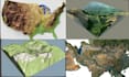
I will create 3d terrain, topographic maps, stl models from contour lines

M
mavics_1
M
mavics_1
Mavics

About this gig

Are you struggling to turn contour lines, topographic maps, Google Earth locations, or elevation data into accurate 3D terrain models? Whether you're an architect, engineer, surveyor, urban planner, game developer, researcher, or 3D printing enthusiast, I can help you create precise, high-quality terrain models tailored to your project.


I specialize in transforming DEM data, contour lines, topographic maps, and real-world elevation data into detailed 3D terrain models optimized for visualization, presentations, simulations, construction planning, GIS projects, and 3D printing.


What you'll get:

  • Accurate 3D terrain and topographic models
  • STL, OBJ, FBX, GLB, and other file formats
  • 3D-print-ready terrain models
  • Terrain generated from contour lines or elevation data
  • Google Maps/Earth location-based terrain
  • Clean, optimized meshes for professional use
  • Fast communication and on-time delivery
  • Commercial-use ready files


I am committed to delivering high-quality work with attention to detail, ensuring your terrain model accurately represents the real landscape and meets your project requirements.


Please contact me before placing an order so we can discuss your project, data, area size

Delivery style preference

Please inform the freelancer of any preferences or concerns regarding the use of AI tools in the completion and/or delivery of your order.

Get to know Mavics

Mavics

Map Designer

  • FromUnited Kingdom
  • Member sinceFeb 2026
  • Languages

    English, Spanish, French, Italian
I am a passionate 3D Map Terrain Designer specializing in creating accurate, high-quality terrain models for 3D printing, visualization, games, architecture, engineering, and GIS applications. I transform real-world landscapes into detailed digital models using DEM, LiDAR, contour lines, satellite imagery, and elevation data. My expertise includes creating custom terrain models in STL, OBJ, FBX, STEP, and other industry-standard formats for clients who need realistic mountains, valleys, coastlines, cities, national parks, and topographic landscapes.