Browse categories
Explore
Fiverr Pro
English
$
USD


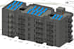
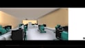

Welcome to the ultimate solution for bridging the gap between Geographic Information Systems (GIS) and Building Information Modeling (BIM)!
If you need to place your architectural models into accurate geographic contexts, analyze utility networks, or execute advanced spatial studies, you are in the right place. I specialize in integrating 3D BIM models into Esri ArcGIS environments to support smart infrastructure and sustainable urban planning.
What I can do for your project:
BIM to GIS Integration: Flawlessly converting and importing Autodesk Revit (.rvt) and AutoCAD (.dwg) models into ArcGIS Pro with full attribute preservation.
Advanced Spatial Analysis: Performing site suitability analysis, terrain/surface analysis, and hydrological modeling.
Utility & Smart Networks: Designing and mapping utility distribution models (Water, Gas, Electrical grids).
GIS Automation: Writing custom Python and C# scripts to automate geodatabase workflows and data manipulation.
Software Expertise:
- Esri ArcGIS Pro & ArcMap
- Autodesk Revit & AutoCAD Civil 3D
- Python, C#, and SQL for databases
Why choose me?
I am an Esri-certified specialist with proven academic and applied experience
Fiverr does not screen freelancers in this category. Please verify qualifications and discuss requirements with the freelancer before ordering, including any preferences regarding the use of AI tools.
BIM and GIS Integration and Spatial Analysis Specialist
Languages
What file formats do you require to start?
I accept Autodesk Revit (.rvt), AutoCAD (.dwg / .dxf), Civil 3D surfaces, shapefiles (.shp), and file geodatabases (.gdb).
Can you automate repetitive tasks in ArcGIS Pro?
Yes, I can write custom Python scripts and build ModelBuilder workflows to automate data extraction, cleaning, and geoprocessing tasks.


