I will do flood risk zoning and mapping using gis by ahp or mcda

M
myk_worker
M
myk_worker
Muhammad Yousaf

About this gig

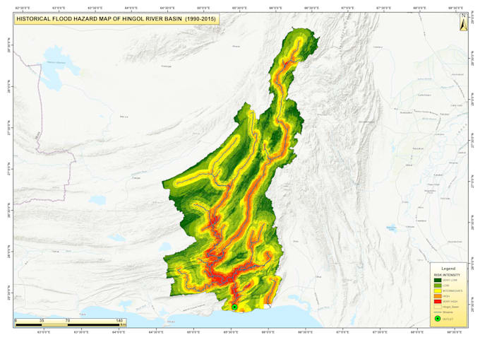
I will perform Flood Risk Mapping and Analysis using GIS to help you identify and visualize flood-prone areas accurately. Using high-resolution DEMs, hydrological and land-use data, I create detailed flood hazard and risk maps for your study area.


My services include:


  • Flood hazard and vulnerability mapping
  • Integration of rainfall, river, and terrain data
  • Flood risk assessment under various scenarios
  • Map layouts, reports, and shapefiles for your project


Whether you need a simple flood map or a full flood risk model, Ill deliver professional results using GIS and hydrological modeling tools.

Software Used: ArcGIS / QGIS / HEC-RAS

Get to know Muhammad Yousaf

Muhammad Yousaf

Water Resources Specialist

5.0(6)
  • FromPakistan
  • Member sinceFeb 2023
  • Avg. response time1 hour
  • Last delivery3 days
  • Languages

    Urdu, Pashto, English
I'm a civil engineer with more than 3 years of Professional Experience. I have expert level proficiency in using GIS, HEC-RAS, HEC-HMS, Global Mapper, Google Earth Pro and MS Office for: 1) Flood Simulation. 2) Hydrological Analysis. 3) Flood Risk Zoning. 3) Managing Raw Data. 4) Cartography (In Case of no Previous Data). 5) Creating Multi-layer Information Layer using GIS. 6) Informative & Aesthetic Maps 7) Documentation To avail any kind of services click on the packages to get your work done as per desired quality and standards.

My Portfolio

Other Data Visualization Services I Offer