Browse categories
Explore
Fiverr Pro
English
$
USD

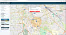
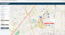

Turn your location data into an interactive WebGIS map that users can explore, search, and understand.
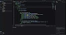
I build custom web maps and GIS dashboards using Leaflet, JavaScript, HTML, and CSS, backed by practical experience in ArcGIS Pro and QGIS.
Depending on your package, features include:
GIS layers with custom styling and layer controls
Markers and informative popups
Location search and attribute filters
Custom sidebars and map navigation
Nearby places search
Routing API integration with distance and estimated travel time
Packages cover one web map with up to 2, 5, or 8 client-supplied GIS layers. You receive source code and setup instructions.
Ideal for property maps, asset visualization, facility finders, planning projects, and location-based applications.
Hosting, paid APIs, data purchases, backend/database development, and substantial data cleaning are quoted separately. Revisions cover adjustments within the agreed scope.
Please message me before ordering with your project area, sample data, and required features so we can confirm the right package.
Geospatial Engineer, Remote Sensing and GeoAI, QGIS Plugin Developer, ArcGIS Pro
Languages


