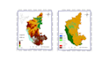
I will create a professional map for your geospatial data

N
nehasinghal21
N
nehasinghal21
Neha S

About this gig

I have more than 6 years of experience in geospatial data analysis and mapping.

I can convert geospatial data into professional, interactive, color-coded maps for easy visualization and interpretation.

I can use multiple tools for data visualization and mapping.

I am comfortable working with ArcGIS, ArcGIS Pro, QGIS, GOOGLE Earth Engine, Python, and R.

I can also create easily interpretable charts and graphs using Excel.


Get to know Neha S

Neha S

Doctoral Researcher Climate Risk Hydrological Modelling

  • FromIndia
  • Member sinceSep 2026
  • Languages

    Hindi, English
I am a Ph.D. in Water Science & Technology with over six years of experience applying climate science, hydrology, and geospatial analytics to solve complex water challenges. My expertise lies in climate risk assessment, drought and flood analysis, and spatial risk mapping using Python, R, and Google Earth Engine. I translate large environmental datasets into actionable insights for climate adaptation.