Browse categories
Explore
Fiverr Pro
English
$
USD

HELLO,
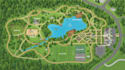
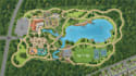
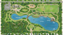
I will design a clean, professional vector park map, recreation map or visitor guide tailored to your location and audience.
I create custom maps for parks, recreation areas, nature destinations, attractions, gardens, campgrounds, visitor centers and outdoor spaces. Your map can clearly show trails, roads, buildings, facilities, activity areas, landmarks, entrances, parking, restrooms, picnic areas and other important points.
I can create the map in a clean vector or illustrated style suitable for:
What I can provide:
Send me your reference material, site plan, sketch, aerial image or existing map, and I can turn it into a polished professional map.
NOTE; message me before order!
Please inform the freelancer of any preferences or concerns regarding the use of AI tools in the completion and/or delivery of your order.
Map designer
Languages
Q: What type of park maps can you design?
A: I can create city park maps, recreation maps, nature park maps, campground maps, garden maps, attraction maps, trail maps and visitor maps.
Q: What do you need to start the project?
A: Please send your existing map, site plan, aerial image, sketch, PDF, reference image or any location information you have.
Q: Can you create the map from an existing site plan or sketch?
A: Yes. I can redraw and organize your existing site plan, sketch or reference into a clean professional vector map.
Q: Can you include trails, facilities and landmarks?
A: Yes. I can include trails, roads, buildings, parking, restrooms, entrances, picnic areas, attractions, activity zones and other important features.
Q: Will the map be suitable for printing?
A: Yes. I can prepare high-resolution, print-ready files suitable for brochures, signage, visitor centers and promotional materials.
Q: Can I get the editable source file?
A: Yes. Editable source files can be included depending on the package you select or added as an extra.
Q: Can you design a visitor guide together with the map?
A: Yes. I can combine the map with a clean visitor-guide layout containing legends, symbols, points of interest and other information you provide.


