Browse categories
Explore
Fiverr Pro
English
$
USD

Level 2

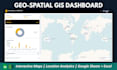
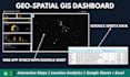
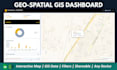

Do you have location-based data but no way to visualize it on a map? I will build you a powerful, interactive geo-spatial dashboard that brings your geographic data to life no GIS software expertise needed on your end.
WHAT YOU GET:
️ USE CASES:
Sales territory performance | Delivery route analysis | Store location comparison | Population data visualization | Logistics and fleet tracking | Real estate market maps | Environmental monitoring
️ TOOLS I USE:
Google Charts (GeoChart) | Leaflet.js | Google Maps API | Apps Script | Excel Power Map | QGIS integration
WHY CHOOSE ME?
Contact Me Now For Efficient And Effective Solutions For Your Needs
Level 2
Languages
What data format do I need to provide?
A spreadsheet (Excel or Google Sheets) with location data — this can be country names, city names, coordinates (lat/long), or postal codes. I will advise on the best approach for your data.
Will the map update automatically when I change the data?
Yes, for Google Sheets-based solutions the map refreshes automatically when you update your data. For Excel versions it refreshes on open or with a button click.
Can the map be embedded in a website?
Yes, Google Apps Script web app maps can be embedded in any website. Let me know if embedding is needed so I can configure it correctly.
Do you work with QGIS or ArcGIS files?
I can import and convert QGIS/ArcGIS datasets into web-based dashboard formats. Share your files and I will advise on the best approach.
Can it show real-time data?
Yes, the Premium package includes real-time data connections via Google Sheets and API integration.


