Browse categories
Explore
Fiverr Pro
English
$
USD


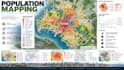
I will create professional population mapping layouts and urban development planning concepts that turn demographic information into clear, visually compelling planning graphics.
I can develop population distribution maps, density mapping, demographic visualization, neighborhood analysis, development patterns, settlement mapping, land-use relationships, growth concepts, urban expansion diagrams, and other planning graphics for cities, districts, communities, and development areas.
These layouts can help communicate where people live, how population density varies across an area, how development is distributed, and how demographic patterns can inform future urban planning decisions.
Whether you have GIS data, population statistics, an existing map, CAD drawing, survey information, PDF, image, or rough planning concept, I can organize the information into a professional and easy-to-understand visual presentation.
The resulting graphics can be suitable for urban planning studies, development proposals, academic presentations, feasibility studies, planning reports, site analysis, public presentations, and professional architecture or urban design portfolios.
I focus on clear
Fiverr does not screen freelancers in this category. Please verify qualifications and discuss requirements with the freelancer before ordering, including any preferences regarding the use of AI tools.
Urban Regeneration Planner Redevelopment Density Land Use Strategy
Languages
What population mapping layouts can you create?
I can create population distribution maps, density maps, demographic visualizations, settlement patterns, neighborhood analysis, and population-based urban planning graphics.
Can you create population density maps?
Yes. Population density can be represented through appropriate mapping graphics, zoning, spatial divisions, labels, diagrams, and other visual techniques.
Can you work with GIS data?
Yes. GIS datasets, existing maps, demographic information, CAD files, statistical data, and other available planning resources can be used as inputs.
Can population data be combined with urban development concepts?
Yes. Population patterns can be visually connected with land use, transportation, development zones, infrastructure, amenities, and urban growth concepts.
Can you create maps for an entire city?
Yes. City-scale population mapping and urban development visualization can be developed when appropriate geographic and demographic information is provided.
