Looking for a skilled GIS expert to take your urban planning projects to the next level? I'm here to help you transform your data into actionable insights with QGIS. Whether you're optimizing trade areas, evaluating land suitability, or mapping accessibility, I provide high-quality, tailored solutions to fit your needs.
My Services:
- Trade Area Analysis: Visualize and understand your market with detailed geographic insights.
- Urban Land Suitability: Find optimal locations for critical infrastructure projects based on economic, accessibility, and health factors.
- Accessibility Mapping: Create maps to improve access to essential services, from eldercare centers to public facilities.
- Service Area Mapping: Design drive-time service areas for fire stations and other critical infrastructure.
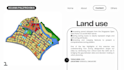
- Zoning & Walkability: Analyze zoning patterns, land use, and street intersection density for better urban design.
- Waste Disposal Mapping: Visualize waste data with proportional-symbol maps to track landfill volumes.
Why Choose Me?
- Personalized Solutions: Tailored to your project needs.
- Expertise & Passion: Deep knowledge of QGIS and urban planning.
- Timely & Reliable: I deliver high-quality results on ti