Basic to Advanced GIS analysis and Map creation & customization
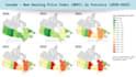
- Customer/People demographic maps (gender, age, income proxies, population density, diversity) to understand target markets
- Economic & regional performance maps highlighting income levels, employment, and growth patterns
- Market & product spread maps showing geographic coverage, demand concentration, and service reach
- Census & survey maps translated into business-friendly insights and KPIs
How the Analysis Is Delivered
- Census & Government Data Integration: Census and open government data (e.g., Statistics Canada) are combined with geographic boundaries to generate demographic, economic, and market-level insights.
- Custom Digitized Spatial Layers: Location-specific points, lines, and polygons are created for customers, services, infrastructure, or regions.
- Spatial Analysis & KPI Modelling: Spatial joins and aggregations are used to calculate market penetration, service coverage %, density, and concentration metrics.
- Presentation-Ready Maps: Clear, executive-ready maps highlighting hotspots, gaps, and opportunities.
Check out samples!