Browse categories
Explore
Fiverr Pro
English
$
USD

You will be working with a LiDAR specialist who understands the full workflow, from field data acquisition to professional processing and analysis.
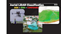
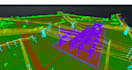
I have completed over 1,000 LiDAR classification and terrain modeling projects on Upwork, including aerial LiDAR and mobile mapping datasets, with more than 6,000 hours of hands-on experience. My expertise focuses on accurate ground / non-ground classification, DEM, DTM, and contour line generation for surveying, engineering, and infrastructure projects.
In addition to data processing, I am an experienced UAV pilot, directly operating professional LiDAR and photogrammetry platforms such as DJI Matrice 300 RTK, Matrice 350 RTK with Zenmuse L1/L2, Matrice 3E/4E/3T, Phantom 4 RTK, Stormbee UAV S20 with FARO scanner, and senseFly eBee Plus. This field experience allows me to fully understand data quality, sensor limitations, and real survey conditions.
Clients choose me for clean and reliable deliverables, strict quality control, fast turnaround, and clear technical communication. My goal is to deliver accurate, optimized LiDAR products ready for immediate use in CAD, GIS, and engineering workflows.
I would be glad to support your project
Geomatics Expert
Languages
1. What data formats do you accept?
I accept LAS, LAZ, E57, PTS, XYZ, RCP and other common LiDAR point cloud formats.
2. Can you do ground / non-ground classification?
Yes. I provide accurate ground and non-ground classification using professional GIS & LiDAR software.
3. Do you provide DTM and DEM?
Yes. DTM and DEM are generated after proper ground classification.
4. What contour intervals can you deliver?
Any interval you need (e.g. 0.5m, 1m, 2m). Please specify before starting.
5. Is this service suitable for UAV LiDAR data?
Yes. I process both UAV LiDAR and terrestrial/mobile LiDAR data.
6. What is the output format?
DTM/DEM: GeoTIFF or ASC Contours: DWG, DXF, SHP, or PDF
7. How accurate are the results?
Accuracy depends on input data quality, but I always aim for high-precision, survey-grade outputs.
8. Can you handle large datasets?
Yes. I have experience processing very large LiDAR datasets (tens to hundreds of GB).
9. Do you follow any standards or workflows?
Yes. I follow standard LiDAR and GIS workflows commonly used in surveying and mapping projects.
10. Can you review my data before ordering?
Absolutely. You can send a sample or details, and I will review it before you place an order.


