Browse categories
Explore
Fiverr Pro
English
$
USD

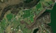
GIS integrates geographical data (spatial locations, maps, topography) with attribute data (information about the assets) to provide a visual representation of the utility's infrastructure - utilities to visualize, analyze, and interpret spatial data to make informed decisions about asset management and operations
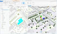
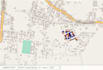
Utility Network is a powerful suite of tools and capabilities designed specifically for managing utility networks such as electric, gas, water, and telecommunications web Gis Developement , Pubishing of Web Services, & Moe.....
Best regards
Prasad
Your One Stop Solution for Telecom Design and Geospatial Services
Languages


