Browse categories
Explore
Fiverr Pro
English
$
USD


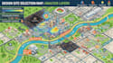
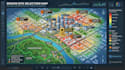
A busy location isn't always the right location.
I turn demographic, competitor, road, property, trade area, and GIS data into a clear site selection map that answers your location questions without clutter.
WHAT THE MAP UNCOVERS:
WHY IT MATTERS?
WHAT SETS IT APART:
You get a map built around the location question you need answerednot a crowded map filled with disconnected points.
Population, demographics, competitors, roads, trade areas, properties, and GIS data can become one visual story.
For retail, restaurants, franchises, real estate, logistics, development, market research, or investment, I make geographic evidence clearer to understand with clarity now.
Send your target area, data, and site selection goal. Let's turn your location data into a map that makes the next site easier to evaluate.
Please inform the freelancer of any preferences or concerns regarding the use of AI tools in the completion and/or delivery of your order.
Vector Map Illustrator
Languages
Will I receive something I can actually use after the project, rather than only a screenshot?
Yes. The final output can be structured for practical review and presentation, with appropriate map elements, legends, labels, scale, and GIS layers. Editable GIS files can also be included when agreed in the package
Can you show more than just where competitors and customers are located?
Yes. The map can reveal spatial relationships such as competitor concentration, demographic clusters, accessibility, trade area overlap, underserved areas, and proximity patterns depending on the data available.
How do I know competitor locations and other map points are positioned correctly?
Locations are checked against the supplied source data and mapped using appropriate geographic references. Where accuracy depends on the quality of your dataset, I flag potential issues instead of hiding them.
What if my demographic or business-location data is incomplete, outdated, or comes from different sources?
I can organize available datasets into a consistent GIS structure and clearly distinguish source based information from derived map analysis. I do not silently fill missing information or present estimates as verified facts.
How do you prevent the map from becoming visually impressive but useless for the actual site decision?
I build the map around the location question first. Demographics, competitors, heatmaps, roads, trade areas, properties, and other GIS layers are included only when they help explain market opportunity, access, coverage, or competitive conditions.


