Unlock the power of Artificial Intelligence (AI), Machine Learning (ML), and Computer Vision (CV) for satellite imagery analysis
I specialize in building and applying deep learning models for extracting critical insights from Earth Observation data. My services support environmental monitoring, urban planning, agriculture, and defense applications with cutting-edge accuracy.
What I Offer
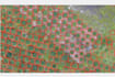
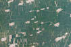
- Land Use / Land Cover (LULC) Classification with Deep Learning (CNNs, U-Nets, Segmentation Models)
- Change Detection (urban expansion, deforestation, waterbody monitoring) using AI
- Object Detection & Tracking (roads, buildings, vehicles, military assets) with YOLO/Mask R-CNN
- AI-Powered Feature Extraction (agriculture, orchards, infrastructure)
- Environmental & Climate Monitoring (pollution, vegetation health, urban heat islands)
- Defense & Strategic Applications:
- Mobility mapping
- Viewshed / Line-of-Sight (LOS) modeling
- Threat & hotspot analysis
- AI-based target detection & clustering
Why Choose Me?
- Expertise in Deep Learning, ML, and CV for Remote Sensing
- Integration of multi-sensor satellite data (Sentinel, Landsat, MODIS, high-res commercial)
- Deliverables in GeoTIFF, Shapefile, KML, or WebGIS-ready f