Browse categories
Explore
Fiverr Pro
English
$
USD


HELLO
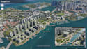
I specialize in creating realistic aerial visualizations that accurately place your proposed development within its actual site context. Whether you're a real estate developer, architect, urban planner, landowner, or investor, these visuals are perfect for marketing, planning applications, client presentations, and investment proposals.
Using SketchUp/Lumion for 3D models + Photoshop for seamless photomontage, I overlay your design accurately on satellite/drone imagery realistic shadows, scaling, and context.
What You'll Get:
Ideal for architects, developers, and agents. Send your 3D model (SKP/Revit), site address, or drone photos quick quote!
Why Me?
Message now to visualize your project in real context! Pricing Packages
Fiverr does not screen freelancers in this category. Please verify qualifications and discuss requirements with the freelancer before ordering, including any preferences regarding the use of AI tools.
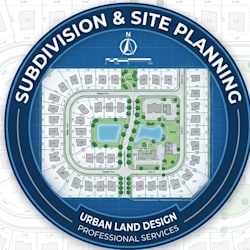
Subdivision, Google Earth Site plan Pool expert
Languages
What do you need to start?
Site address/Google Earth coords, 3D model or 2D plans, drone photos (if any).
Tools used?
SketchUp, Lumion, Photoshop, Google Earth Pro.
How realistic?
Full photomontage with shadows/perspective match.


