Browse categories
Explore
Fiverr Pro
English
$
USD


️ ARCHITECT & REAL ESTATE EXPERT | PRECISION AERIAL MAPPING SOLUTION
Are you struggling with outdated site plans, inaccurate land surveys, or missing topographic data for your construction, real estate, or development project?
I transform raw drone imagery and aerial data into professional, survey-grade deliverables that architects, developers, and real estate professionals rely on for decision-making.
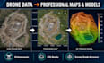
️ WHAT I DELIVER
Orthomosaic Maps Georeferenced, high-resolution 2D site maps
3D Terrain & Surface Models (DTM/DSM) Accurate elevation data for earthworks and planning
Point Cloud Processing Dense, classified point clouds for CAD/GIS import
Contour Line Generation Custom interval topographic maps
GIS-Ready Data Packages Shapefiles, GeoTIFFs, KML/KMZ for ArcGIS, QGIS, AutoCAD
Volume Calculations & Cut/Fill Analysis Essential for construction bidding
3D Mesh & Textured Models For visualization, presentations, and BIM workflows
WHY CLIENTS CHOOSE ME
Dual expertise: Licensed architecture background + real estate development experience
Survey-grade accuracy using Pix4D, Agisoft Metashape, Drone2Map & Global Mapper
Fast turnaround without compromising precision
Fiverr does not screen freelancers in this category. Please verify qualifications and discuss requirements with the freelancer before ordering, including any preferences regarding the use of AI tools.
Architectural Sketch Artist,Concept Design, Building Visualization
Languages
What software do you use for processing?
I use industry-standard platforms including Pix4Dmapper, Agisoft Metashape, Esri Drone2Map, and Global Mapper. I select the best workflow based on your project requirements and desired output format.
Do I need to provide ground control points (GCPs)?
GCPs are strongly recommended for survey-grade accuracy (sub-5cm). Without GCPs, I can process using onboard GPS with accuracy typically within 1-3 meters. I can guide you on GCP placement if needed.
What drone data formats do you accept?
I accept JPEG, TIFF, RAW images with embedded GPS metadata. I also process DJI Phantom, Mavic, Matrice, and Autel datasets. For LiDAR, I accept .las, .laz, and .e57 formats.
Can you deliver CAD-compatible files?
Yes. I export to DXF, DWG, Shapefile, GeoTIFF, KML, and point cloud formats (LAS, PLY, XYZ) compatible with AutoCAD, Civil 3D, ArcGIS, QGIS, and Revit.
How accurate are the final deliverables?
With proper GCPs, accuracy is typically 1-3 cm horizontally and vertically. Without GCPs, accuracy depends on drone GPS quality, usually 1-3 meters. I'll specify expected accuracy in my delivery notes.


