Browse categories
Explore
Fiverr Pro
English
$
USD
Spatial Repair and Optimization, Done Intelligently
Need help with geospatial data, mapping, or file conversions?
I've got you covered.
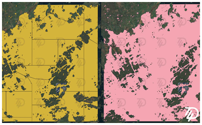
Need to convert massive geospatial files, fix broken polygons, or enrich your data with new attributes? You're in the right place. I specialize in handling complex GIS tasks with precision, speed, and clarity.
Whether you're working with GPKG, KML, SHP, GeoJSON, or other formats, I offer tailored solutions that scale with your needsnot just your file size.
What I Offer:
Whether you're a researcher, analyst, or just someone stuck with a tricky GIS file, I'll make sure your data is clean, usable, and ready to go.
Lets make your geospatial work easier, faster, and smarter.
Each package is designed to reflect the time and complexity of the task. Whether you're fixing geometry, converting large files, or enriching your data with new attributes, the effort scales similarly and so does the pricing.

What if my file is small but has hundreds of broken polygons?
That’s exactly why I tier by effort. Message me with your file details and I’ll guide you to the right package—or create a custom offer.
Can you simplify geometry for better performance?
Yes! I simplify geometry to reduce unnecessary edges while preserving shape accuracy—so your polygons load faster and perform better in tools like Power BI, mobile apps, and web maps.
Will the files work in my platform or tool?
I tailor files for compatibility with Power BI, QGIS, Google My Maps, Leaflet, Mapbox, ArcGIS, Tableau, and more. Just let me know your target platform and I’ll optimize the output.
What about CRS or projection settings?
I default to EPSG:4326 (WGS84) for wide compatibility, but I can reproject to other coordinate systems on request.
Can you check my data or idea before I order?
Absolutely. Send a sample or describe what you're building, and I’ll let you know what’s possible before you commit. I’m happy to guide you to the right package or offer a custom quote.
Can you add calculated fields like area or centroid?
Yes! I can enrich your data with calculated attributes such as area, centroid coordinates, bounding boxes, and more—just let me know what you need.
Do you handle large or compressed files?
Definitely. I work with files up to 100GB+ and can extract layers from compressed or multi-layer formats like GPKG or ZIP archives.
| (1) | ||
| (0) | ||
| (0) | ||
| (0) | ||
| (0) |
mrmrssquirrel

Finland
I needed a bunch of files converted from multiplelinestrings to polygons / geojson or kml. Like 100,000 big. I was doing it all manually and obviously taking forever. Bro was able to sott through a lot of data (in another language) and deliver. All I needed to do was to explain what I needed, and...
$50-$100
Price
13 days
Duration
| (1) | ||
| (0) | ||
| (0) | ||
| (0) | ||
| (0) |
mrmrssquirrel
Finland
I needed a bunch of files converted from multiplelinestrings to polygons / geojson or kml. Like 100,000 big. I was doing it all manually and obviously taking forever. Bro was able to sott through a lot of data (in another language) and deliver. All I needed to do was to explain what I needed, and...
$50-$100
Price
13 days
Duration