Browse categories
Explore
Fiverr Pro
English
$
USD

1 order in queue
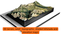
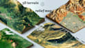
I create terrain visualizations from suitable elevation data, turning geographic information into a clear, professional result.
SERVICES
DELIVERABLES
Depending on your package, receive a high-resolution map image or terrain model in an agreed format such as STL or OBJ. Deliverables are confirmed before work begins.
HOW IT WORKS
Send your location, boundary or source data and intended use.
I review the data, detail level, dimensions, style and output.
I create the agreed map or model for your review.
Each project is scoped to your location and purpose, with attention to terrain detail, clean presentation and clear communication.
Message me before ordering for large areas, specific GIS workflows, unusual formats or print-ready models. Results depend on available elevation data and requested detail.
Send your requirements and let's find the right solution.
Please inform the freelancer of any preferences or concerns regarding the use of AI tools in the completion and/or delivery of your order.
Custom 3D Terrain Maps, Landscape, Topography, Game Worlds
Languages
What do you need from me to create a custom terrain or relief map?
Please provide the location name or coordinates, a boundary or area of interest, and your preferred map style. If available, attach elevation data such as a DEM, GeoTIFF, or other relevant source file. Also specify the intended use, desired dimensions, output format, and level of detail.
What is the difference between a relief map, a shaded relief map, and a topographic map?
A relief map emphasizes the shape and elevation of the land. A shaded relief or hillshade map uses simulated lighting and shadows to reveal terrain features. A topographic map may include contour lines, elevation information, and other geographic details.
Can you create 3D terrain maps for 3D printing?
Yes, where the source data and project requirements are suitable. I can assess terrain modeling for formats such as STL or OBJ, depending on the agreed workflow. Please specify the desired physical dimensions, geographic area, level of detail, and intended printing method
Which file formats can you deliver?
Depending on the project, possible outputs include PNG map images and 3D model formats such as STL or OBJ. Other formats may be available if supported by the workflow. Please state your required format before placing an order so I can confirm compatibility
Can you map any location, and how long will the project take?
Many locations can be assessed, but the achievable detail depends on the available elevation data, geographic coverage, and requested scale. Standard projects may take three to seven days according to the selected package.


